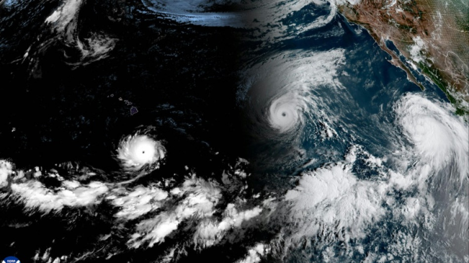
Rare train of Pacific cyclones fueled by historic El Nino / Photo: Handout - NOAA/AFP

 London
 19 °C
19 °C
 Manchester
18 °C
Manchester
18 °C
 Glasgow
17 °C
Glasgow
17 °C
 Dublin
20 °C
Dublin
20 °C
 Belfast
19 °C
Belfast
19 °C
 Washington
 24 °C
24 °C
 Denver
 31 °C
31 °C
 Atlanta
35 °C
Atlanta
35 °C
 Dallas
37 °C
Dallas
37 °C
 Houston Texas
36 °C
Houston Texas
36 °C
 New Orleans
32 °C
New Orleans
32 °C
 El Paso
35 °C
El Paso
35 °C
 Phoenix
38 °C
Phoenix
38 °C
 Los Angeles
27 °C
San Diego
26 °C
San Francisco
21 °C
Chicago
36 °C
Minneapolis
31 °C
Seattle
18 °C
Portland
15 °C
Salt Lake City
29 °C
Las Vegas
34 °C
Miami
29 °C
Jacksonville
30 °C
San Antonio
38 °C
Bermuda
Los Angeles
27 °C
San Diego
26 °C
San Francisco
21 °C
Chicago
36 °C
Minneapolis
31 °C
Seattle
18 °C
Portland
15 °C
Salt Lake City
29 °C
Las Vegas
34 °C
Miami
29 °C
Jacksonville
30 °C
San Antonio
38 °C
Bermuda
 30 °C
Nassau
21 °C
Iqaluit
15 °C
Yellowknife
21 °C
Anchorage
13 °C
Fairbanks
30 °C
Nassau
21 °C
Iqaluit
15 °C
Yellowknife
21 °C
Anchorage
13 °C
Fairbanks
 6 °C
Barrow
2 °C
Calgary
24 °C
Edmonton
36 °C
Winnipeg
25 °C
Goose Bay
26 °C
Halifax
23 °C
Boston
22 °C
Ottawa
25 °C
Toronto
24 °C
Detroit
36 °C
Cleveland
34 °C
New York
21 °C
Baltimore
24 °C
Philadelphia
23 °C
Nuuk (Godthåb)
5 °C
Hong Kong
26 °C
Singapore
6 °C
Barrow
2 °C
Calgary
24 °C
Edmonton
36 °C
Winnipeg
25 °C
Goose Bay
26 °C
Halifax
23 °C
Boston
22 °C
Ottawa
25 °C
Toronto
24 °C
Detroit
36 °C
Cleveland
34 °C
New York
21 °C
Baltimore
24 °C
Philadelphia
23 °C
Nuuk (Godthåb)
5 °C
Hong Kong
26 °C
Singapore
 28 °C
Melbourne
30 °C
Canberra
28 °C
Melbourne
30 °C
Canberra
 12 °C
Adelaide
13 °C
Darwin
23 °C
Perth
14 °C
Fort Worth
37 °C
Honolulu
27 °C
Sydney
19 °C
Johannesburg
12 °C
Adelaide
13 °C
Darwin
23 °C
Perth
14 °C
Fort Worth
37 °C
Honolulu
27 °C
Sydney
19 °C
Johannesburg
 17 °C
Dubai
35 °C
Mumbai
28 °C
Zürich
20 °C
Tokyo
26 °C
Seoul
21 °C
Delhi
27 °C
Beijing
19 °C
Riyadh
35 °C
Prague
19 °C
Pennsylvania
24 °C
Valletta
28 °C
Manama
34 °C
Warsaw
17 °C
Stockholm
15 °C
17 °C
Dubai
35 °C
Mumbai
28 °C
Zürich
20 °C
Tokyo
26 °C
Seoul
21 °C
Delhi
27 °C
Beijing
19 °C
Riyadh
35 °C
Prague
19 °C
Pennsylvania
24 °C
Valletta
28 °C
Manama
34 °C
Warsaw
17 °C
Stockholm
15 °C
Two powerful hurricanes and a strengthening tropical storm on Wednesday were churning through the Pacific Ocean where waters were being warmed by a historically strong El Nino climate episode.
Furthest west is Hurricane Lowell, followed by Hurricane Karina. Both of the Category 4 storms are anticipated to pass well to the south and to the northeast of Hawaii, respectively, according to the National Hurricane Center (NHC).
However, there remains uncertainty about their forecast tracks, with the possibility of gustier trade winds and increased rainfall impacting the islands as a result of Lowell.
Hawaii is still recovering from the impacts of Hurricane Lala, which brushed past the southern part of Big Island, bringing destructive winds and severe flash floods.
Hurricanes Lowell and Karina are trailed to the east by Tropical Storm Marie, currently a few hundred miles south of Baja California and "expected to become a hurricane later today," the NHC said.
"El Nino warming sets the stage for these storms, which are fuelled in large part by warm waters -- when the tropical Pacific is warmer than normal we see an increase in strong storms," climate scientist Julia Cole of the University of Michigan told AFP.
A train of three cyclones "is definitely rare to see," she added.
A similar train of four cyclones happened in 2015, another intense El Nino year when Typhoon Kilo, Hurricane Ignacio, Hurricane Jimena and Tropical Depression 14E all worked their way west across the Pacific at once.
This year's El Nino has a 69 percent chance of becoming the strongest on record, according to the National Oceanic and Atmospheric Administration, and is already unleashing extreme weather across the globe even though it is not expected to peak sometime around November.
Peru, the world's largest catcher of anchovy, is facing a devastating blow from warming seas that have gutted production, according to industry officials. In Sudan, El Nino is blamed for delaying crucial rains that have led water levels in the Nile to drop precipitously.
El Nino is the warming phase of a natural cycle in the tropical Pacific known as the El Nino-Southern Oscillation (ENSO), and comes along every two-to-seven years.
It sets in when trade winds that blow from east to west temporarily ease up, allowing warm water which normally piles up in the western Pacific Ocean to slide back east and rise to the surface.
When those warmer-than-average surface temperatures last for a few months, they cause more storms and clouds over the region, which in turn cause ripple effects through the entire global atmosphere: hotter and drier conditions in some places, cooler and wetter in others.
Climate change increases El Nino's impacts. Because the greenhouse-gas-warmed atmosphere holds more moisture, El Nino-linked rains can turn more extreme. It also dries out soils, deepening drought where El Nino brings drought.
There is less consensus on whether climate change itself triggers stronger El Ninos, though evidence for this is emerging -- including a recent study of coral skeleton record published in Science that revealed El Ninos have grown significantly more intense in the last 40 years compared to the pre-industrial period.
(D.Lewis--TAG)